The Search for the Original Biafra: Where Did the Name Come From?
Published on: 6th August 2026
For centuries, the name Biafra has resonated as a powerful geographical, historical, and geopolitical identity in West Africa. While modern global memory associates the name primarily with the Bight of Biafra and the late 19th-to-20th-century history of South-Eastern Nigeria, the origins of the word stretch back to the earliest decades of European Atlantic exploration.
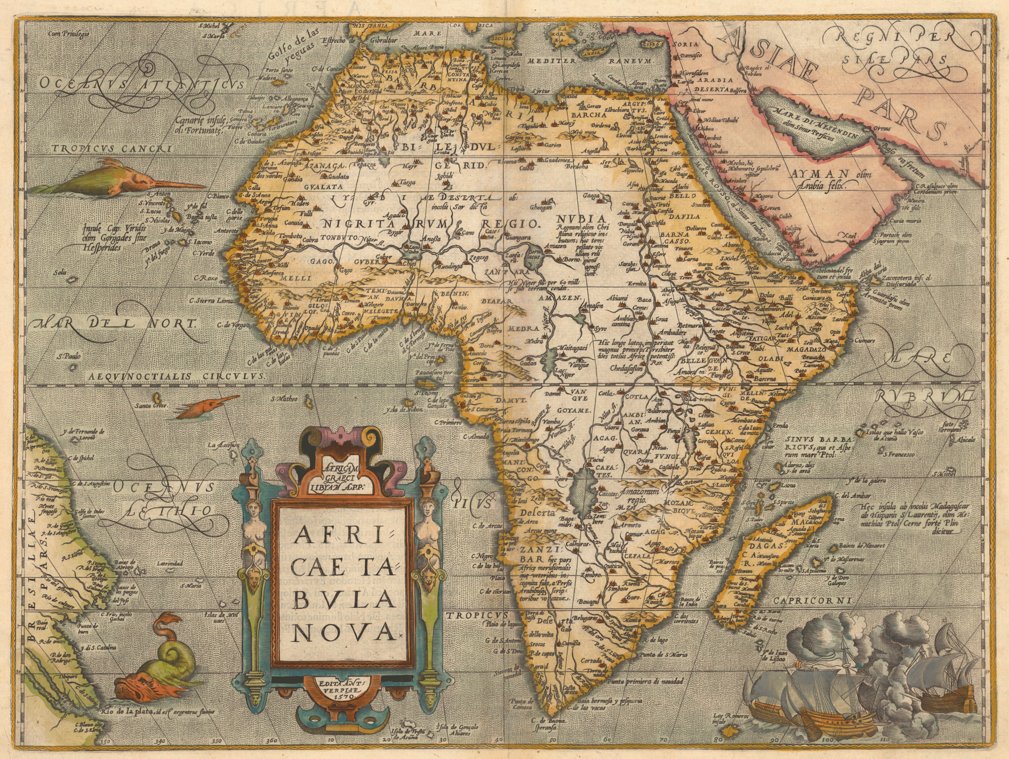
Long before the era of modern nation-states, European cartographers inscribed the label Biafara, Biafar, Beafara, and eventually Biafra across the Gulf of Guinea and deep into the uncharted interior of Central Africa. This raises a fundamental historical question: Was Biafra originally an inland kingdom, a coastal region, or a European geographical construct?
Furthermore, a persistent enigma in West African historical geography remains: Why did early Portuguese navigators apply the name Biafara to two distinct, widely separated geographic areas in West Africa—first in the Senegambia/Rio Grande region (modern Guinea-Bissau) and later in the Bight of Biafra (modern Nigeria/Cameroon)? Examining early Portuguese charts, 17th-century geographical treatises, and comparative West African naming patterns reveals the true origin and evolution of the name Biafra.
Part I: The Cartographic Footprint of Early Biafra
When Portuguese navigators under the patronage of Prince Henry the Navigator and later King John II began mapping the West African coastline in the 15th century, they recorded both coastal hydrography and interior political structures reported by local traders. The term Biafra did not materialize out of thin air; it left a distinct chronological footprint across early European cartography.
[EARLY CARTOGRAPHIC EVOLUTION OF BIAFRA]

1502: Cantino Planisphere
└── First coastal entries near the Bight / Rio dos Camarões

1505: Caverio Map
└── Standardizes coastal placement east of the Niger Delta

1552: João de Barros' "Ásia"
└── Documents Portuguese diplomatic/trade networks in the Bight

1668: Olfert Dapper's "Description of Africa"
└── Details the inland "Kingdom of Biafar" and its political status

1670: John Ogilby's "Africa"
└── Translates & expands Dapper's account of Biafra's interior state
1. The Cantino Planisphere (1502)
One of the earliest surviving depictions of the West African coastline incorporating Portuguese discoveries is the Cantino Planisphere (1502). Smuggled out of Lisbon for the Duke of Ferrara, the map accurately outlines the bend of the Gulf of Guinea. In the region east of the Niger Delta—extending toward the volcanic peak of Mount Cameroon and the Rio dos Camarões (River of Prawns / Wouri River)—cartographic labels begin to designate the surrounding waters and hinterlands as Biafara.
2. The Caverio (Canerio) Map (c. 1505)
Created shortly after the Cantino map, Nicolay de Caverio’s chart solidified the placement of Biafara east of the Rio Real (the Bonny/New Calabar river mouth) and the Bight of Benin. On the Caverio map, the orthography alternates between Biafara and Biafar. The label is applied not merely to an open bay, but is anchored firmly to the landmass framing the bight.
3. Early Portuguese Textual References & Maps (16th–17th Centuries)
By the mid-16th century, Portuguese chronicles—such as João de Barros’ Décadas da Ásia (1552)—and Dutch/English cartographic treatises regularly referenced the region. Cartographers like Diogo Ribeiro (1529) and later Gerardus Mercator (1569) elevated Biafara from a mere coastal marker to a vast interior territory. Maps from this era frequently feature "Biafara Regnum" (The Kingdom of Biafara) printed in bold gothic lettering, positioned east of the Kingdom of Benin and north of the Kingdom of Manicongo.
Part II: Kingdom, Region, or European Invention?
To answer whether Biafra was originally a kingdom, a region, or a European linguistic construct, we must evaluate three primary hypotheses.
┌──────────────────────────────────────────────┐
│    WAS BIAFRA ORIGINALLY A...                │
└──────────────────────┬───────────────────────┘
                       │
┌──────────────────────┼───────────────────────┐
▼                      ▼                       ▼
[INLAND KINGDOM]      [COASTAL REGION]     [EUROPEAN HYBRONYM]
Supported by:         Supported by:        Supported by:
• Dapper (1668)       • Bight naming       • Linguistic corruptions
• Ogilby (1670)         conventions        • Dual geographic usage
• Maps of "Biafara    • Coastal trade      • Toponym reapplication
  Regnum"               anchors
                      • Maritime charts
Hypothesis A: An Inland Kingdom
The assertion that Biafra was a concrete political state rests heavily on 17th-century European geographical literature, most notably Olfert Dapper’s Nauwkeurige Beschrijvinge der Afrikaensche Gewesten (1668) and its English translation/expansion, John Ogilby’s Africa (1670).
Dapper and Ogilby describe Biafar or Biafara not merely as a coastline, but as a powerful inland realm. Ogilby notes that the "Kingdom of Biafar" lay east of Benin, bordered by the realm of Mujac (in the interior) and extending toward the Cameroonian highlands. According to these accounts:
- The kingdom possessed a central monarch who exercised sovereign authority over surrounding tributary lands.
- It maintained active trade routes bringing ivory, wax, and captives toward the coast to exchange with European vessels.
- It was politically distinct from both the Kingdom of Benin to its west and the sovereign polities of the Congo basin to its south.
However, modern historiography urges caution when reading Dapper and Ogilby. Neither author visited West Africa directly; both compiled accounts from Portuguese, Dutch, and Spanish sailors, traders, and missionaries. European cartographers of the Renaissance possessed a horror of blank spaces on maps (horror vacui). When coastal traders reported strong, organized polities deep in the interior—such as the Eze Nri (the sacred priest-king of the Nri Kingdom), the Attah of Idah (Igala Kingdom), or the confederated states of the Cross River and Cameroonian hinterlands—European mapmakers frequently synthesized these reports into a single, unified "Kingdom of Biafara."
Thus, while an organized, powerful inland political entity (or cluster of polities) indisputably existed, the specific label Biafara Regnum was largely a European cartographic consolidation of these interior powers.
Hypothesis B: A Coastal Region
The second possibility is that Biafra was primarily a hydronym and regional designation—a name assigned by European mariners to describe the distinct curve of the Atlantic Ocean between the Niger Delta and Cape Lopez.
Maritime navigation in the 15th and 16th centuries required precise coastal nomenclature. The Gulf of Guinea was divided into two distinct indentations:
- The Bight of Benin: Extending from the Volta River to the Nun mouth of the Niger River.
- The Bight of Biafra: Extending from the Niger Delta eastward to Cape Formosa, the Calabar/Cross River estuaries, and south to Cape Lopez.
Under this model, Biafra functioned identically to terms like the Gold Coast, the Grain Coast, or the Slave Coast—a geographical descriptor used by mariners to navigate trade zones, which only later became attached to the land and its people.
Hypothesis C: A Local Ethnic or Linguistic Term
The third and most compelling thesis is that the name derived from a local ethnonym or language group encountered by the Portuguese near the coast, which European tongue corrupted into Biafara.
In West African linguistic geography, European sailors rarely invented names from whole cloth. They routinely adopted local names for rivers, headlands, and ruling groups, transliterating them into Portuguese phonetics.
- Benin derived from the Edo word Ubini.
- Escravos derived from the Portuguese word for slaves, but applied to a specific river trade hub.
- Camarões derived from the Portuguese word for prawns, applied to the Wouri River.
Linguists and historians suggest that Biafara originated as a European transliteration of an indigenous self-name or exonym used by coastal groups in the Niger Delta and Cameroonian borderlands.
Part III: Comparative Naming Patterns—The Benin Analogy
To understand how Biafra developed as a geographic name, it is useful to analyze the structural parallel between the Bight of Benin and the Bight of Biafra.
+-----------------------------------------------------------------------------------+
|                        WEST AFRICAN NAMING CONVENTIONS                            |
+-----------------------------------------------------------------------------------+
|  POLITY / ETHNICITY              COASTAL WATER BODY           INTERIOR REALM      |
+-----------------------------------------------------------------------------------+
|  Ubini / Benin (Edo)        ──>  Bight of Benin          ──>  Kingdom of Benin    |
|                                                                                   |
|  Biafara / Beafada / Biafar ──>  Bight of Biafra         ──>  Kingdom of Biafara  |
+-----------------------------------------------------------------------------------+
In the case of Benin, the pattern of transmission is crystal clear:
- The Core Polity: The Edo people established the powerful Kingdom of Benin (Ubini).
- European Contact: Portuguese explorers under Ruy de Sequeira (1472) and João Afonso de Aveiro (1486) established direct diplomatic and trade relations with the Oba of Benin.
- The Water Body: Because the Kingdom of Benin was the dominant regional power controlling trade along the western coast, European mariners named the adjacent gulf The Bight of Benin.
Applying this comparative model to Biafra, a clear historical principle emerges: European mariners named bights after the major political or ethnic entities controlling the adjacent coastline.
The designation Bight of Biafra strongly implies that when the Portuguese navigated east past the Niger Delta, they encountered an ethnic group, trade network, or political authority identified as Biafar or Biafara. Just as the Bight of Benin derived its name from the Kingdom of Benin, the Bight of Biafra derived its name from a recognized coastal or near-coastal polity/ethnonym of Biafara.
Part IV: The Great Portuguese Puzzle—The Two Biafras of West Africa
One of the most remarkable yet under-examined phenomena in early Atlantic history is that Portuguese navigators applied the exact same name—Biafara / Beafada / Beafara—to two completely separate locations in West Africa.
THE TWO BIAFRAS OF WEST AFRICA

WESTERN BIAFRA                         EASTERN BIAFRA
(Upper Guinea Coast)                   (Bight of Biafra)

• Location: Guinea-Bissau /            • Location: Nigeria / Cameroon
  Rio Grande region                      border region
• People: Beafada (Biafada)            • People: Efik, Ibibio, Igbo,
  ethno-linguistic group                 Duala, and inland polities
• Contact: 1450s–1460s                 • Contact: 1470s–1480s
1. The First Biafra: Upper Guinea (Guinea-Bissau)
In the mid-15th century (c. 1450s–1460s), Portuguese explorers navigating the Upper Guinea coast—near the Geba and Rio Grande rivers in modern-day Guinea-Bissau—encountered an indigenous Atlantic ethnic group. The Portuguese transcribed their name as the Biafadas, Beafares, or Biafares.
- These Beafada (Biafada) people were a distinct ethno-linguistic group closely related to the coastal Atlantic language family.
- They established prominent trading polities along the Rio Grande, actively trading ivory, gold, and rice with Portuguese coastal traders (lançados).
- Portuguese maps of the 15th and 16th centuries explicitly label this region in Upper Guinea as the country of the Biafares or Beafaras.
2. The Second Biafra: Lower Guinea (Nigeria / Cameroon)
A decade or two later (c. 1470s–1480s), as Portuguese ships rounded the bend of the Gulf of Guinea past the Niger Delta, they applied the exact same term—Biafara / Biafar—to the coastal hinterlands of modern South-Eastern Nigeria and Cameroon.
Part V: Why Did the Portuguese Reuse the Name? The Linguistic Connection
Why did 15th-century Portuguese navigators use the same name for two places separated by over 2,000 miles of coastline? Was it pure coincidence, cartographic error, or a shared root meaning?
1. The Theory of Toponymic Reapplication (Transplanted Names)
In early maritime exploration, European navigators frequently recycled geographical terms across different coastal regions. When sailors encountered familiar environmental features, trade setups, or coastal profiles, they often reused names from earlier voyages.
However, in the case of Biafra, the linguistic structure is too specific to be a random naming error. The root B-F-R or F-A-R-A appears in both West African coastal contexts.
2. The Ethno-Linguistic Root: What Did "Biafara" Mean?
Linguistic analysis of Atlantic and Niger-Congo language families offers crucial insights into why this root word appeared in both regions:
- The Upper Guinea Root (Be-afada / Bia-fada): In the languages of the Upper Guinea coast, prefixes like Be- or Bia- frequently denote "people of" or "dwellers of," while fara or fada relates to land, rivers, or open country. Thus, Beafada translated natively to "the people of the land/river."
- The Gulf of Guinea Root (Bia-fara / Bia-fra): In the coastal languages surrounding the Bight of Biafra—specifically among the coastal trade networks of the Cross River, the Niger Delta, and the Cameroonian estuaries—similar phonetic roots existed. The root Bia or Bie in several coastal Delta languages signifies "water," "stream," or "settlement," while fara / pala denotes broad, open territories or trade routes.
3. Shared Characteristics Leading to Name Reuse
When Portuguese mariners arrived in the Bight of Biafra in the 1470s, they observed striking economic and geographical similarities to the Rio Grande region of Upper Guinea:
| Feature | First Biafra (Guinea-Bissau) | Second Biafra (Nigeria/Cameroon) |
|---|---|---|
| Geographic Environment | Highly indented coastal estuary with complex mangrove rivers (Rio Grande). | Highly indented coastal estuary with complex mangrove rivers (Niger/Cross Delta). |
| Indigenous Trade | Riverine canoe-based trading networks exchanging interior goods. | Riverine canoe-based trading networks exchanging interior goods. |
| Sociopolitical Structure | Decentralized, highly spiritual coastal polities linked to inland trade lords. | Decentralized, highly spiritual coastal polities linked to inland trade lords (e.g., Nri, Efik houses). |
Because the Portuguese mariners relied on African interpreters and coastal guides, they encountered phonetic terms that sounded identical to their ears. Finding an estuarine river system populated by riverine traders using a phonetically similar root word, Portuguese scribes standardized the name Biafara for the second region just as they had for the first.
Conclusion: The True Nature of Biafra
Synthesizing early maps, 17th-century texts, and historical linguistics resolves the debate over the origin of Biafra:
- It Was Originally an Ethnonym and Regional Descriptor: Biafra was not an imaginary European invention, nor was it originally a single centralized empire. It began as a local ethno-linguistic term (Biafara / Biafar) used by coastal traders in the Gulf of Guinea, which Portuguese navigators adopted in the late 15th century.
- It Evolved into a Cartographic Kingdom: As early Portuguese maps like the Cantino (1502) and Caverio (1505) recorded the name, later 17th-century geographers like Dapper and Ogilby consolidated the powerful inland trading polities of the region—including spiritual centers like Nri and trade hubs along the Niger/Cross rivers—under the unified label "Biafara Regnum."
- The Dual-Name Phenomenon: The reuse of the name between Upper Guinea (Beafada) and Lower Guinea (Biafra) highlights how early Portuguese mariners applied familiar West African phonetic roots to similar estuarine, riverine trading societies across the continent.
Ultimately, Biafra represents a historic synthesis: a native West African root word describing coastal and riverine people, adopted by Portuguese maritime explorers, mapped by Renaissance cartographers, and permanently etched into the geographical memory of West Africa.