Biafra Reconsidered: Interior Peoples, Coastal Interpreters, and the Linguistic Origins of a Cartographic Name
Published on: December 2025
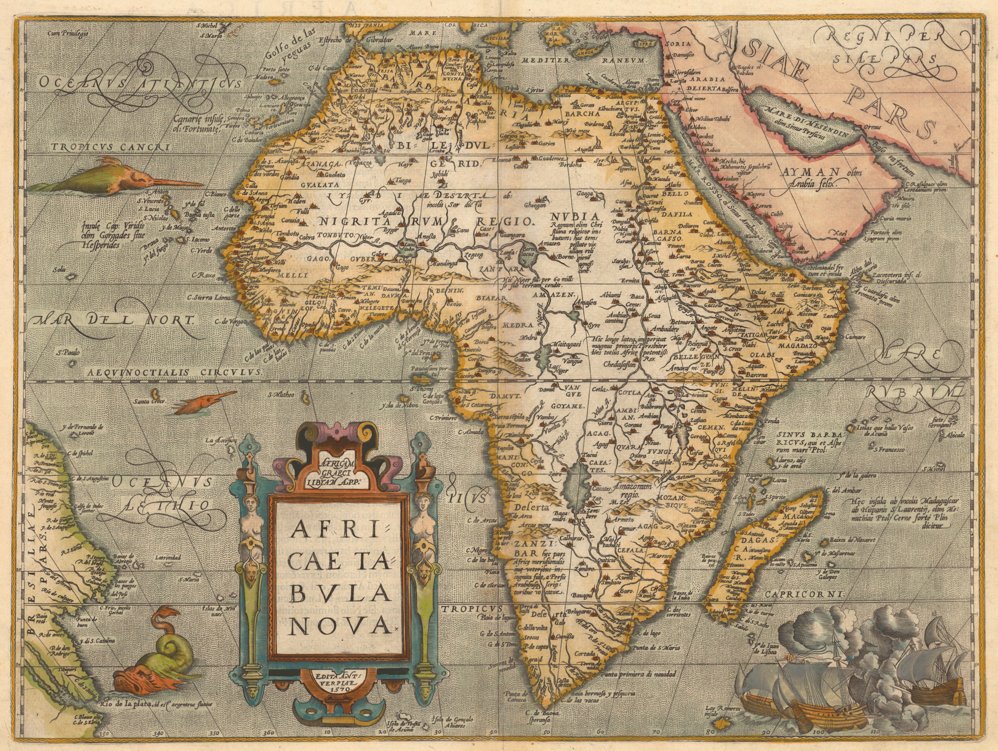
The name “Biafra” appears on European maps of West–Central Africa from the late fifteenth century onward, often positioned in the interior, east of the Niger Delta and west of the Cross River–Cameroon zone. Despite its repeated appearance in early cartography, the origin of the name remains poorly understood. Popular explanations that trace “Biafra” to Portuguese language or Portuguese towns fail under linguistic and historical scrutiny. A closer examination of regional African languages, combined with early European mapping practices, suggests a more plausible explanation rooted in African descriptive speech rather than European invention.
Introduction
This article advances a careful linguistic hypothesis: that “Biafra” originated as a European transcription of descriptive phrases used by coastal peoples to refer to interior populations. Rather than being an indigenous ethnonym or a Portuguese name, “Biafra” appears to reflect how African intermediaries described inland communities to early European visitors. This argument is grounded in language evidence from southeastern Nigeria and western Cameroon, as well as the interior placement of the name on early maps.
The Geographic and Linguistic Setting
The region historically labeled as Biafra lies inland from the Atlantic coast, within or adjacent to areas inhabited by Igbo-speaking populations, and bordered by Efik, Ibibio, Oron, Ejagham (Ekoi), and western Cameroonian language groups. Importantly, early European explorers did not penetrate these interior regions in the fifteenth and sixteenth centuries. Their geographic knowledge came largely from coastal traders, riverine communities, and interpreters.
This means that any inland name appearing on early European maps must be understood as second-hand information, filtered through the linguistic frameworks of coastal African speakers rather than direct European observation.
The Meaning of Bi / Bia in Regional Languages
Across southeastern Nigeria and western Cameroon, bi or bia functions primarily as a verb related to motion, presence, or residence. While specific usage varies, the semantic core remains consistent.
- In Igbo, bia means “to come,” while related constructions using bi express “to live,” “to stay,” or “to reside.” For example, ndi bi n’ime ala refers to people who live inland.
- In Efik and Ibibio, cognate forms convey meanings such as “to be,” “to stay,” or “to come,” especially in locative descriptions.
- In Ejagham (Ekoi), similar verbs indicate being present, arriving, or dwelling in a place.
- In Grassfields languages of western Cameroon, related forms exist meaning “to come” or “to arrive,” though with different phonetic realizations.
Crucially, bi or bia is not a noun and not an ethnonym in any of these languages. It functions as a descriptive verb, commonly used when explaining where people live rather than who they are as a named group.
The Meaning of Afara / Fara / Vara
The second component, afara and its variants fara or vara, is equally important. Across Cross River and western Cameroonian linguistic zones, this term consistently refers to spatial access rather than people or places.
- In Efik, Ibibio, and Oron, afara or ufara denotes an opening, passage, or crossing, often associated with river mouths or navigable creeks.
- In Ejagham, cognate forms refer to gaps, openings, or access routes in forested or riverine landscapes.
- In Bakweri and Balondo languages of southwestern Cameroon, fara or vara similarly denotes mouths or openings where land and water systems connect.
Importantly, afara does not mean water itself, forest, town, people, kingdom, or source of a river. It denotes a point of transition or access, especially within river and creek systems.
Interior Placement and Coastal Description
On early European maps, Biafra is consistently located inland rather than on the coast. This placement strongly suggests that the term was not a self-designation used by interior peoples, but rather a coastal description of them. When Europeans asked coastal communities who lived inland or beyond the rivers, the answers were likely framed in everyday descriptive language.
A coastal speaker might describe interior populations as people who live or stay beyond the river passages. Such a description would be meaningful locally but could easily be misunderstood by outsiders as a proper name.
From Description to Cartographic Name
Early European mapmakers frequently mistook descriptive phrases for fixed place names. This pattern is well documented across Africa, the Americas, and Asia. Once a phrase was written onto a map, it was often copied repeatedly, even after its original grammatical meaning was lost.
Phonetically, a phrase resembling bi afara would have been easily rendered by Portuguese scribes as Biafara, later standardized as Biafra. Portuguese orthographic habits often fused words, smoothed vowel transitions, and regularized endings. Over time, a functional description hardened into a permanent cartographic label.
What Biafra Was and Was Not
Based on linguistic and cartographic evidence, Biafra was not a Portuguese word, not the name of a Portuguese town, not an indigenous ethnonym meaning forest or bush, and not the name of a centralized precolonial kingdom. Instead, it was most plausibly a European transcription of African descriptive speech referring to interior populations accessed through riverine openings.
Conclusion
Biafra did not originate as a national or ethnic self-designation. Its roots lie in the everyday descriptive language of southeastern Nigerian and western Cameroonian coastal societies. Verbs of dwelling such as bi or bia and nouns of access such as afara were used to describe inland peoples and spaces. When early European mapmakers recorded what they heard, description became name. Over centuries, that name endured long after its original meaning faded.
Understanding Biafra in this way restores historical context rather than diminishing significance. It reveals the term as a linguistic trace of early African–European encounters, preserved on maps long after the conversations that produced it disappeared.
References
- Afigbo, A. E. (1981). Ropes of Sand: Studies in Igbo History and Culture.
- Hair, P. E. H. (1967). The Early Study of Nigerian Languages.
- Talbot, P. A. (1926). The Peoples of Southern Nigeria.
- Greenberg, J. H. (1963). The Languages of Africa.
- Law, R. (1991). The Slave Coast of West Africa.
Disclaimer: This article is for educational and historical discussion purposes only. It presents a linguistic hypothesis grounded in documented language patterns and cartographic evidence. Readers are encouraged to consult primary linguistic and historical sources for further research.